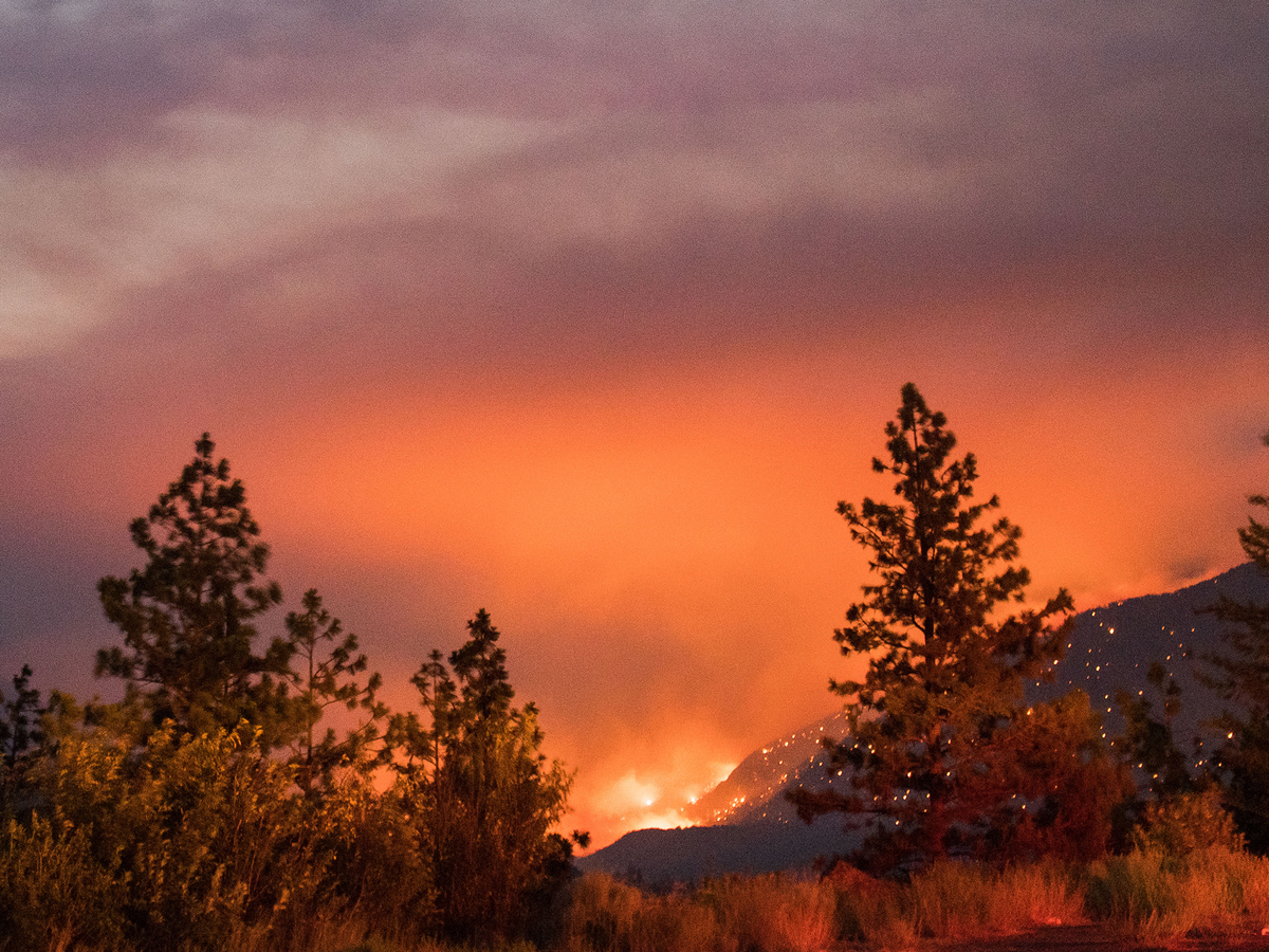
A few days ago, a wildfire started in north Texas and grew quickly, driven by strong southwesterly winds. Named the Smokehouse Creek Fire, it has burned more than 1.1 million acres and is now the largest wildfire in Texas history. The mainstream media has been quick to blame climate change for the fire, with headlines like this one from NBC News: Wildfires ravage Texas amidst climate change crisis, or this one from ABC13 in Houston: How climate change is increasing wildfire risks across Texas. These stories are false; multiple lines of real-world data refute any connection between these fires and climate change.
NBC News claims:
The Texas Panhandle is no stranger to face-blasting winds nor roller-coaster dips in temperature. But the fires would not have had the same chance to take off if not for unseasonably warm temperatures and dry conditions made more likely by climate change.
ABC13 claims:
Additionally, climate change could increase Texan’s risks for wildfires over the next 30 years. ABC13 Meteorologist Elyse Smith has previously covered this topic through ABC’s Weathering Tomorrow initiative, which uses data from our partners at the First Street Foundation. It shows how wildfire risk, as well as heat, flood, and wind risks, will be impacted by climate change through the year 2050.
If either of these news outlets had bothered to do a ‘fact check,’ they would find their claims are unsupported by real world data.
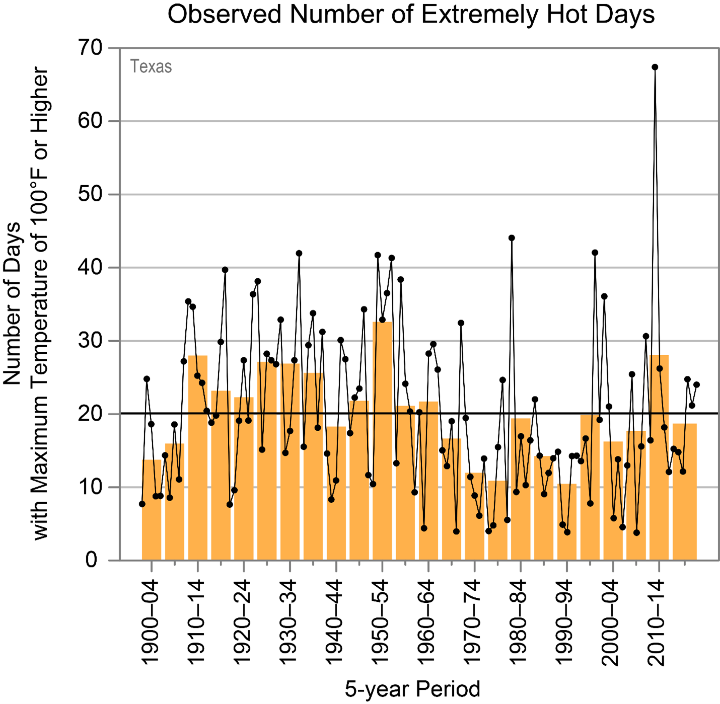
Figure 1 – From 1910 through 1964 the number of hot days was actually greater than the current period of time.
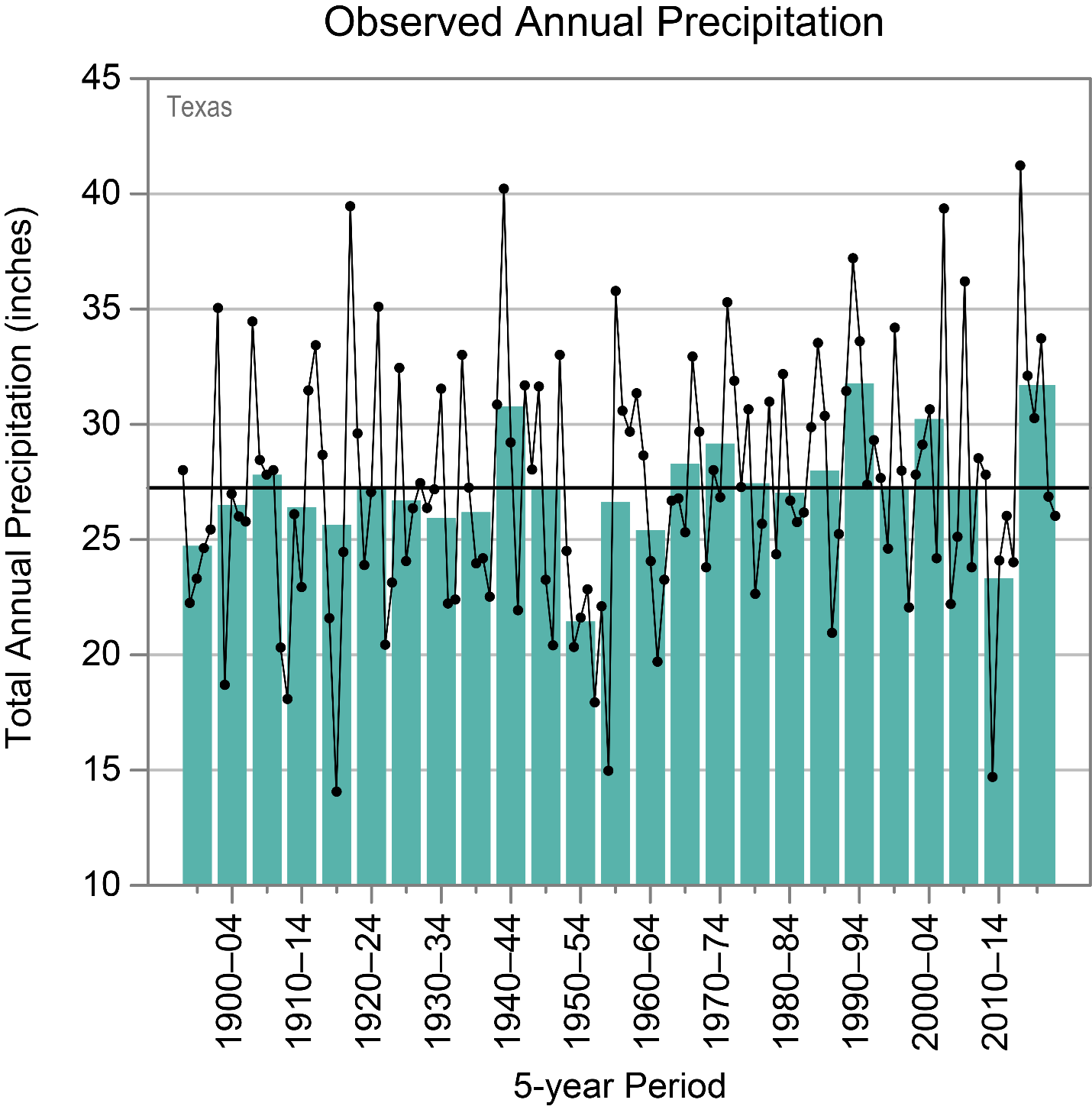
Figure 2 – From 1970 to the present, average annual precipitation for Texas increased.
With fewer hot days and increased precipitation recorded in the long-term climate records, the claim that Texas is more susceptible to wildfires now that in the past because of climate change is clearly false.
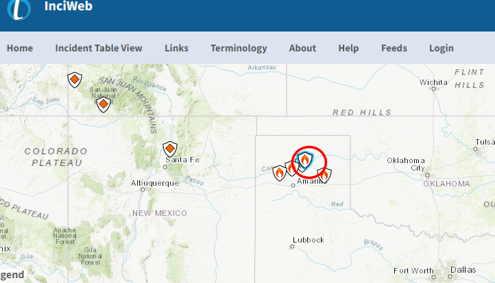
Both media outlets suggested that the area where the fires are is drier than normal. This too is false. Here is a map from InciWeb showing the location of the Smokehouse Creek Fire (circled in red) in Figure 3.
Figure 3 – location of the Smokehouse Creek Fire.
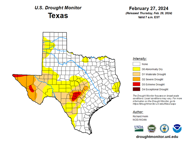
According to the US drought monitor, the area now beset by the wildfire is not abnormally dry and certainly not experiencing drought conditions:
Figure 4 – U.S. Drought Monitor map of Texas for Feb27, 2024. Note most of the upper Texas panhandle area is not in drought.
Nor is the adjacent region of Oklahoma caught up in the wildfire suffering under abnormally dry or drought conditions.
Wildfires, especially in arid parts of the United States, have always been a natural part of the environment, and they likely always will. Global warming did not create wildfires. In fact, wildfires have become less frequent and less severe in recent decades. One of the key contributing factors has been that the United States has experienced fewer droughts in recent decades than in periods throughout the twentieth century.
Even the most recent International Panel on Climate Change (IPCC) assessment of global climate agrees. On Page 90 – Chapter 12 of the UN IPCC Sixth Assessment Report. Emergence of Climate Impact Drivers (CIDs) the table in Figure 5 shows the incidence of “Fire weather” has not emerged from climate change:
Figure 5: note that Fire Weather has not emerged from climate change being a driver.
Actual data and various lines of hard evidence show that there is no connection between climate change and the wildfires now ravaging parts of north Texas and Oklahoma, or anywhere else for that matter. Sadly, once again the media is pushing the “climate catastrophe,” narrative in which every extreme weather event or natural disaster is caused by climate change, despite the clear evidence that this is false. In this case, rather than doing investigative due diligence, neither NBC nor ABC bothered to check facts before publishing these scare stories, which suggests that their reporters and editors are either lazy, incompetent, blinded by political ideology, or all three.
The Maui Government is going to release a large amount of Vinyl Acetage to the Ocean that's surrounds the Hawaiian islands, claiming its "SAFE" to discharge when it's not! 😡
Once the damage is done, they'll declare a National Emergency, quarantine, and grab the land later. 👇🧐 pic.twitter.com/EzAQWXxBvn
Chicago’s skyline with heavy smoke from Canada’s wildfires, seen from the 360 Chicago Observation Deck of the John Hancock Building in Chicago, Illinois on June 27, 2023. KAMIL KRZACZYNSKI / AFP via Getty Images
Smoke from Canada’s wildfires in Ontario and Québec has dipped south into the U.S. once again, causing air quality alerts to be issued for more than 80 million people in the Midwest and parts of the East Coast, reported CNN. In some areas, people have been advised to remain indoors and beaches have been closed.
This has been the worst fire season ever recorded in Canada, with more than 257 of the 485 active wildfires yesterday burning out of control, the Canadian Interagency Forest Fire Centre said, according to The New York Times.
The current air quality in Chicago, Indianapolis, Pittsburgh and other cities in the Midwest stretching east is “very unhealthy,” according to AirNow.gov.
A white haze hung over Chicago, and residents were advised to stay indoors, CNN reported.
Chicago Park District said in a tweet that their camps and other programs would be held indoors “to the fullest extent possible.”
“I can feel like a burning in my throat,” Dalya Khuder told CNN affiliate WXYZ while visiting Detroit. “The air quality is just really bad and I don’t want that stuff in my lungs.”
According to Copernicus, part of the European Union space program, Canada has seen the highest annual emissions ever recorded as a result of the wildfires.
“There’s particularly poor air quality… over southern Wisconsin, Illinois, central Indiana, and also another area over southeast Michigan, Detroit and northeast Ohio around Cleveland,” National Weather Service meteorologist Byran Jackson said on Wednesday, as reported by PBS. “This is particularly thick smoke.”
The smoke and poor air quality was again headed for New York and other East Coast locations.
“Another round is going through western New York, western Pennsylvania later today,” Jackson said. “And then that continues over the northern Mid-Atlantic. It will persist there into Thursday.”
Air quality alerts were also in effect in Washington, DC, and parts of North Carolina, Reuters reported.
About 16 million acres have already been burned by the wildfires in Canada — an area slightly larger than the state of West Virginia.
People living in areas where an air quality alert has been issued, especially elderly people, children and those with respiratory illnesses, have been urged to stay inside, wear a mask and limit heavy or prolonged exertion.
“Don’t generate extra particles indoors if you can,” said Dr. Peter Moschovis, a pulmonologist at Massachusetts General Hospital and an assistant professor at Harvard Medical School, as reported by NBC News. “So, smoking, vaping, burning incense, aerosolized essential oils — all those things aren’t good for your lungs at baseline.”
The most recent Intergovernmental Panel on Climate Change report said conditions that are hot, dry and windy make fires more likely, and these conditions will occur more frequently if the climate crisis continues to worsen.
In a study from 2018, Canadian scientists found that, since 1959, there has been a marked increase in the amount of large fires in the country, and that the fire season has begun about a week earlier and ended a week later.
“We know that human-induced climate change is warming Canada at about twice the global average rate,” said Nathan Gillett, a research scientist at the Canadian government’s environment department,” as BBC Future reported.
BREAKING: New reports indicate deadly vinyl chloride has contaminated the Ohio River as far as West Virginia, a water source for over 5 million! pic.twitter.com/tEkGArIEUd
Four companies that developed solar energy facilities in Alabama, Idaho and Illinois have agreed to pay a total of $1.3 million for violating construction permits and rules for handling groundwater, authorities said Monday.
A statement by the Justice Department and the Environmental Protection Agency said the companies used a common construction contractor. In each case, the government alleged companies failed to take steps to control runoff water. In Alabama and Idaho, sediment from construction sites got into nearby waterways, the government said.
The cases involved AL Solar A LLC, which built a solar farm near LaFayette, Alabama; American Falls Solar LLC, which owned a site near American Falls, Idaho; Prairie State Solar LLC, owner of a development in Perry County, Illinois; and Big River Solar LLC, which had a development in White County, Illinois, according to the statement.
The solar farm owners are all subsidiaries of large international companies, the government said.
AL Solar will pay $500,000 in civil penalties to state and federal regulators, it said, and American Falls will pay a civil penalty of $416,500 to the federal government. The Illinois sites remain under construction, and officials there have to follow the rules for the remainder of the work.
It’s time once again, gentle readers, to look in on, with appropriate fear and trembling, the bold, new, tranformatively transforming electric vehicle transformation. We begin with an article from Just The News from December of 2021, a matter that has gone mostly under the radar:
President Biden has signed a series of executive orders to make the federal government carbon neutral.
The Democrat president on Wednesday [12-08-21] ordered federal agencies to purchase electric vehicles, harness wind, solar, and nuclear energy to power facilities, and to use sustainable building materials. The goal is for the federal government to stop adding carbon dioxide to the atmosphere by 2050.
In the next decade, Biden wants the government to cease purchasing electricity produced from sources that emit carbon dioxide. By 2035, the administration wants all new federal cars and truck purchases to be zero-emissions. Right now, only about 1.5% of the government fleet is electric vehicles. The government buys about 50,000 vehicles a year. In fiscal 2021, only 650 of those were electric.
This is, of course, wildly irrational and physically impossible. The charging infrastructure for such a fleet isn’t remotely in place, and it’s a certainty local power providers would have to significantly upgrade their hardware to accommodate the necessary chargers wherever they were installed. Ad that to the fact there isn’t enough power capacity to charge the vehicles now, and the Administration isn’t doing a thing to prevent nuclear, coal and gas plants from going off-line—precisely the opposite. D/S/Cs still have no idea from where electricity comes, and they’re doing nothing to educate themselves. They simply mandate things and expect them to magically appear, you know, like when you plug something into the wall, there’s electricity!
As part of its recently passed infrastructure bill, the Biden administration plans to spend $7.5 billion building 500,000 chargers for electric vehicles. But will drivers actually want to use those chargers?
The two biggest impediments to the widespread adoption of electric vehicles are the vehicles’ range and their upfront cost. Right now there are only five varieties of electric vehicles with a range of more than 350 miles per charge, and none of them retail for a base price of less than $47,000. And while the Build Back Better Act passed by the House last month contains tax rebates for new electric vehicle purchases, none of the five qualify for the full amount. For comparison, a base model Ford Focus costs considerably less and can go further on a full tank of gas.
Check that: a base price of less than $47,000. Base prices for any model of vehicle are the absolute lowest that vehicle can cost, and dealers order very few, if any, of those vehicles. They exist mostly for PR, bragging right purposes. Various sources place the current EV average at $63,000 dollars, which is luxury vehicle territory. EVs are currently bought by the upper 7% in income of the population. Oh yes, that 350 mile range? That’s an optimistic, best possible situation guess. Actual range, with drivers driving as they would a conventionally fueled vehicle, is considerably less.
It’s no joke; EV battery replacement costs run 1/3 or more of the MSRP of the vehicle, and it’s absolutely not a pull one out, plug the other one in, evolution.
Conveniently placed vehicle chargers could mitigate the range issue: Ideally, a trip to a charger would simply replace a trip to the fuel pump. But the Biden plan is unlikely to fix this problem. There are two types of public vehicle chargers, Level 2 and Level 3. (Level 1 uses a standard power outlet.) Level 2 chargers produce around 25 miles of range per hour, meaning that a full charge from empty could take five hours or longer. Level 3 chargers produce considerably more power, and can charge some vehicles from empty to 80 percent in as little as 15 minutes. But while Level 2 chargers cost less than $3,000 apiece, Level 3 chargers cost as much as $140,000 each to build. There is no indication which the administration prefers, but if it plans to build 500,000 for $7.5 billion, it’s almost certainly going to have to settle for Level 2 chargers.
Time, as they say, is money. If one uses an EV only for a short daily work commute, and there are enough conveniently placed chargers available, that might work. But if one can afford only one car for every possible driving situation, it would be impossible. Imagine needing to travel say 300 miles, carefully altering—extending–your route to be near a charger, and arriving with 25 miles of range left—it will actually be less—only to find the charger is out of service, or there is already someone charging their vehicle, and you have a four hour wait until you can begin charging. And it’s the dead of winter or the heat of summer, and the entire family is along, which also considerably shortens your range, and if it’s cold, it will take longer to charge and you’ll have less range…
Toyota Motor Corp.’s leader criticized what he described as excessive hype over electric vehicles, saying advocates failed to consider the carbon emitted by generating electricity and the costs of an EV transition.
Toyota President Akio Toyoda said Japan would run out of electricity in the summer if all cars were running on electric power. The infrastructure needed to support a fleet consisting entirely of EVs would cost Japan between ¥14 trillion and ¥37 trillion, the equivalent of $135 billion to $358 billion, he said.
‘When politicians are out there saying, ‘Let’s get rid of all cars using gasoline,’ do they understand this?’ Mr. Toyoda said Thursday at a year-end news conference in his capacity as chairman of the Japan Automobile Manufacturers Association.
He said if Japan is too hasty in banning gasoline-powered cars, ‘the current business model of the car industry is going to collapse,”’ causing the loss of millions of jobs.
In a country such as Japan that gets most of its electricity from burning coal and natural gas, EVs don’t help the environment, Mr. Toyoda said. ‘The more EVs we build, the worse carbon dioxide gets,’ he said.
He said he feared government regulations would make cars a ‘flower on a high summit’—out of reach for the average person.
Ah yes: the sweet sound of reality. What Mr. Toyoda knows and is willing to say is EVs are not, in fact, better for the environment than gas powered vehicles. All of the energy and pollutants necessary to produce an EV greatly exceeds that necessary to build a conventional vehicle, and the difference is not made up by electric charging. There’s that inability or unwillingness of D/S/Cs to accept electricity is produced almost exclusively by coal, oil, natural gas or nuclear power sources. When I see coal trains a mile long rolling out of Wyoming, I think:
Word on the mean streets of Detroit is that the Ford Motor Company is planning on axing 8,000 salaried workers in order to boost profits to help fund future electric vehicles (EV).
*The auto giant’s goal is to save $3 billion in costs by 2026
*Ford’s other goal is to build 2 million EVs by 2026
*They also intend to produce electric F-Series trucks
‘As part of this, we have laid out clear targets to lower our cost structure to ensure we are lean and fully competitive with the best in the industry,’ Ford’s Chief Communications Officer Mark Truby said in a statement.
Ford announced on Sept 27, 2021, that they were planning to build EV-related factories in Tennessee and Kentucky, which will supposedly create 11,000 jobs.
As if driving an electric F-150 isn’t enough to give a man Low-T, the factories themselves will be painfully green as well.
Mrs. Manor and I drive a 2016 F-150 and a 2022 Ford Escape, vehicles with which we are both well pleased. Back in June of 2021, I chronicled a summer trip in the F-150,carrying three passengers, a fully loaded bed, and hauling a U-Haul trailer loaded with a motorcycle and everything else we could jam into it across much of Wyoming and South Dakota. By all means, take the link, but the upshot is, the F-150, with 325 horsepower, performed admirably, with expected lowered mileage, against fearsome headwinds. A comparable EV would have been a disaster, as I explain.
It would also be worthwhile to visitthis YouTube video of a towing contest between a new F-150 Lightning EV and a conventionally powered GMC pickup. They towed identical trailers, and the F-150 did very, very badly. Consider this:
While the GMC Sierra Denali doesn’t really need to do much to prepare apart from top off the fuel, the same does not apply to the Ford pickup. The first issue, before even beginning the top off of the battery charge, is the charging station. Unfortunately, the charging station and most charging stations are a pull-in design which means that unless the driver parks and unhitches the trailer, drives to the station, charges, then goes back to the trailer to hook up, he will be blocking either the roadway or any other charging ports.
See the video, gentle readers. It would also be worth your while to visit this Motor Trend report of Lightning towing capacity. I’ll do a stand alone article on this in the near future, but suffice it to say it was a disaster. If Ford is putting its future in the EV basket, I fear for my future ability to find parts and service for what are our excellent, carefully chosen, vehicles. Pickups of any kind just aren’t that popular on the blue coasts or in blue cities, and people living in Flyover country who buy most of Ford’s trucks and SUVs, can’t afford EVs, and know they’re incapable of meeting their needs.
But let’s visit a May 22, 2022 article at Watts Up With Thatto explore the wonderful world of electric public transit, this time in Paris, France:
A video recording shows the start of the fire which completely consumed an electric RATP bus on Friday 29 April. The incident caused no injuries. The bus burst into flames within seconds. This is what can be seen on the video that captured the very beginning of the fire of an electric vehicle of the RATP in Paris , this Friday, April 29. In the images, we can see a small explosion occur on the roof of the bus, where the batteries are located, followed by huge flames that spread to the entire body, at breakneck speed. This line 71 bus caught fire in the 13th arrondissement of Paris in the morning, mobilizing around thirty workers, according to the firefighters contacted by Le Parisien. It is a 100% electric vehicle, from the Bolloré brand Bluebus 5SE series, like the bus that burned down at the beginning of April.
This afternoon, the RATP decided to temporarily withdraw from circulation the 149 Bolloré electric bluebuses that circulate on its network.
About all that was left was a melted lump on the pavement. But what about the US, where electric public transit is the wave of the future? Let’s visit a local media article about another blazing bus:
One day after officials touted the passage of the Connecticut Clean Air Act, including plans for thousands of electric vehicles to hit the road, one of the state-run electric buses caught on fire over the weekend.
The blaze engulfed a CT transit bus in a Hamden parking lot Saturday morning, sending two workers and a firefighter to the hospital, officials said.
‘Lithium ion battery fires are difficult to extinguish due to the thermal chemical process that produces great heat and continually reignites,’ Hamden fire officials said.
‘The bus, last operated on July 20, on routes 243 and 265, and was not in service at the time of the incident,’ Rickman said. ‘Bus fires are rare, but can occur similar to cars. This is CT transit’s first fire incident with a battery electric bus. Bus operators, maintenance staff and others undergo extensive training and safety protocols are in place.’
As a result of the fire, the electric bus fleet was pulled from service as a precaution, Rickman said.
This fire too left a smoking pavement lump. What the article is not telling you is EV batteries contain extremely volatile substances, which must be kept separated. If allowed to mix by even a pinhole, the results are violent, explosive and immediate. Manufacturers have been reluctant to admit the danger, but some (ahem, cough: Chevy and the Chevy Bolt) have suggested their vehicles should not be recharged at home in a garage, or left unsupervised when charging–something about EVs spontaneously bursting into flames, and garages and homes too. Imagine sitting and watching an EV recharge, outdoors, for hours on end.
The bold, brilliant EV future, gentle readers, forcibly coming to you in the near future?
Comment *
Rum on Most people do not realize that putting an ever higher density of electrons into a battery, which is what so many are trying to do, runs the risk of it suddenly turning into a bright blue fireball bigger than the vehicle carrying it. High performance batteries are like liquid fuel rockets. Both components for the energy producing reaction are always on board and close together. Neither needs air/oxygen to make them burn at full force. All they need is a “short” connecting + to – or kerosene to liquid oxygen. Both of these dangers can express themselves quite violently and pouring water on it does not work to quench the melt down because neither needs air.. Reply
Giant Sequoia trees in the western Sierra Nevada range in California have been severely damaged and estimates have said somewhere between 2,261 and 3,637 sequoia trees have been lost this year, alone.
This has been a bad year but last year was even worse as an estimated 7,500 to 10,400 trees were lost to wild fires, according to the Associated Press. That means the lightning strikes in California have destroyed nearly 20% of all giant sequoias in the last two years. The giant sequoia is the Earth’s largest trees and are native to about 70 groves in the western Sierra Nevada range in California.
These giant sequoia trees were once considered nearly fireproof, but are being destroyed in wildfires at rates that are alarming experts. Fires in Sequioa National Park and the surrounding national forest that also bears the trees’ name tore through more than a third of the groves in California in the last two years.
Officials said the overall rising temperature of the planet in addition to a historic series of droughts in California, along with decades of fire suppression tactics have allowed such intense fires to ignite that it could cause the destruction of so many of the trees, many of which are thousands of years old.
Over the centuries the giant sequoia has adapted to have a bark thick enough to protect itself from the lower intensity of fires that were commonly ignited by lightning strikes in the region previously.
The lower intensity fires even help the trees, clearing other vegetation so the great sequoia can continue to grow and the fire will open the cones, causing the tree to release seeds. However, due to the dry and hot environments, the fires of the past several years have burned too hot for the seed to grow, endangering the areas where the most trees were burned.
California has seen its largest fires in the past five years, with last year setting a record for the most acreage burned. So far, the second-largest amount of land has burned this year.
Superintendent of Sequoia and Kings Canyon National Parks said, “The sobering reality is that we have seen another huge loss within a finite population of these iconic trees that are irreplaceable in many lifetimes. As spectacular as these trees are, we really can’t take them for granted. To ensure that they’re around for our kids and grandkids and great-kids, some action is necessary.”
Some Los Angeles-area beaches were closed to swimmers on Monday after 17 million gallons of untreated sewage spilled into the Pacific Ocean.
Sanitation officials said the Hyperion Water Reclamation Plant in Playa del Rey had become “inundated with overwhelming quantities of debris” after a power outage, triggering the plant’s relief system to discharge the waste matter through a pipe one mile offshore.
Hyperion Executive Plant Manager Timeyin Defeta said in a statement that the “emergency measure” was necessary “to prevent the plant from going completely offline and discharging much more raw sewage.” He added, “Normally the discharge of treated sewage is through the five-mile outfall.” According to the L.A. Times, “Dafeta said he believes that the incident was the largest amount of untreated sewage discharged through the one-mile pipe over the last 10 years,” and “the one-mile pipe was last used for a major discharge of wastewater in 2015.”
17 million gallons of sewage is about 6% of a daily load, Defeta said.
The L.A. County Department of Public Health issued a beach closure order on Monday affecting swim areas around Dockweiler State Beach and El Segundo Beach. They will remain closed until water samples are confirmed negative for elevated bacteria.
On Monday afternoon, L.A. County Supervisor Janice Hahn tweeted, “We are going to need answers about how and why this happened.”
“Protocols for notifying regulatory agencies and the State’s Office of Emergency Services were followed,” said Defeta on Monday. “Water quality sampling and testing of shoreline (beach) samples are currently being conducted, and our monitoring vessel traveled to both outfalls to make observations and take samples for analyses following regulatory permit protocols.”
Shortly after taking this picture a lifeguard approached me and said that 17 million gallons of sewage were dumped in this ocean last night… he did say that I would want to take a good long shower tonight as well which I will be doing pic.twitter.com/TtwhEM327Q
At about noon on Sunday, a large amount of debris unexpectedly clogged filtering screens with openings less than an inch in size at the treatment plant, said Barbara Romero, the director of L.A.’s Department of Sanitation and Environment.
The plant’s managers tried adding screens to replace the ones that were blocked. They also tried redirecting the flows to a storm drain system within the plant — an alternative way to bring the water through the normal treatment process.
But after several hours of recirculating the water, the system was still too overwhelmed…
So about 7:30 p.m., plant workers discharged the wastewater one mile out and 50 feet deep into the ocean. The normal process directs treated wastewater 190 feet down.
According to Romero, sanitation workers successfully routed the flows of water back through the standard treatment process around 4:30 a.m. on Monday.
Heal the Bay, an environmental nonprofit dedicated to protecting coastal waters of Greater L.A. warned that “bacteria and viruses in raw sewage are extremely dangerous to people and can carry a variety of diseases.”
The group posted information about the discharge on its website and urged people to stay out of Santa Monica Bay until further notice.
PUBLIC HEALTH ALERT: 17 million gallons of raw sewage were spilled into the Santa Monica Bay on 7/11-7/12. Dockweiler State Beach and El Segundo Beach are closed to the public. We recommend staying out of the water. We’ll keep you updated as we learn more.https://t.co/8sP1MplBKapic.twitter.com/PNl7QJlu9u
“Debris such as tampons and plastic trash, when released into the Bay, can harbor bacteria and can cause entanglement of wildlife, but it seems in this case that debris were successfully filtered out of the spill before it made it to the Bay.”
The Daily Wire is one of America’s fastest-growing conservative media companies and counter-cultural outlets for news, opinion, and entertainment. Get inside access to The Daily Wire by becoming amember.
Wildfire burns above the Fraser River Valley near Lytton, British Columbia, Canada, on Friday. James MacDonald/Getty Imageshide caption
Jeannette Muhammad
Wildfire burns above the Fraser River Valley near Lytton, British Columbia, Canada, on Friday.
James MacDonald/Getty Images
Emergency responders in Canada are currently battling more than 180 wildfires in British Columbia amid an intense heat wave that has left hundreds dead in the Pacific Northwest.
About 70% of the active fires were likely caused by lightning strikes, according to the British Columbia Wildfire Service’s dashboard. Chris Vagasky, a meteorologist with the company Vaisala, says a lightning detection network uncovered more than 700,000 lightning strikes in the area between June 30 and July 1.
About 95 miles northeast of Vancouver, residents in the village of Lytton were forced to evacuate to avoid a spreading fire that began Wednesday afternoon.
While two residents have already been confirmed dead by the British Columbia Coroners Service, others are still missing.
For three days, Lytton suffered through record-breaking heat, reaching up to 121 degrees Fahrenheit. Then on Wednesday, the fire started and the village’s roughly 250 residents were forced to flee.
Lytton resident Jeff Chapman was with his parents as they noticed smoke and flames in the distance. He helped them climb into a freshly-dug trench, before fleeing when he realized there wasn’t enough space. The fire arrived in just 10 minutes, he told the CBC.
He ended up lying near railroad tracks only to watch a power line fall on top of the trench where his parents were.
“I just can’t get it out of my mind,” Chapman told the network.
Now about 90% of Lytton is burned, according to Brad Vis, a member of Parliament representing the area.
In response to Lytton’s devastation, Prime Minister Justin Trudeau announced federal aid would be sent to help the village rebuild.
The fires come amid a massive heat wave for the region. Extreme heat can intensify the risk of wildfires.
Lisa Lapointe, chief coroner for the British Columbia Coroners Service, said last week in a statement that 486 “sudden and unexpected deaths” had been reported in the last six days of June.
“͞While it is too early to say with certainty how many of these deaths are heat related,” Lapointe said, “it is believed likely that the significant increase in deaths reported is attributable to the extreme weather B.C. has experienced and continues to impact many parts of our province.”
The coroners service said between June 25 and July 1, 719 overall deaths were reported, which is three times the number that would be expected for the same period.
The U.S. is also being pummeled by heat, with the northwest and north-central U.S. feeling extreme temperatures. Many areas continue to experience temperatures in the 90s and 100s, according to the National Weather Service.
Scientists say the warming climate is making heat waves more frequent and intense. The health risks from them may also be greater early in the summer, when people are less accustomed to higher temperatures.
On September 29th, the first messages appeared on the Internet, drawing people’s attention to the state of the Khalaktyrsky Beach (Kamchatka Krai). Witnesses stated that the shore was covered with dead animals’ bodies. In addition, surfers complained about vision problems, symptoms of poisoning, and fever after contact with water. In a number of cases, after visiting a doctor, people were diagnosed with ocular chemical injuries.
On September 30th, the Acting Minister of Natural Resources and Ecology of Kamchatka Krai reported, based on results of water sampling and quality assessments, that «… in one of the samples an excess of almost 4 times was found for oil products, in two samples – an excess of 2 times for phenols. During the extraction of samples, the glass of the chemical glassware was covered with an oily substance of a bright yellow color, which, may indicate the presence of a pollutant that is similar in properties to industrial oil.»
On October 1st, Kamchatka Interdistrict Environmental Prosecutor’s Office initiated investigation of the information spreading on media concerning pollution of ocean water in the area of Khalaktyrsky beach.
On October 2nd, the updated data of the chemical analysis of water samples confirmed an increase of approximately 2.5 times for phenols and 3.6 times for oil products.
On October 3rd, Ministry of Natural Resources and Ecology of Kamchatka Krai posted on Instagram the following statement: «The color of the water is normal, the smell of the air is normal, the beach is completely clean», which contradicts the testimony of divers claiming thousands of dead animals.
The fact that this pollution has been continuing for more than two weeks, despite the past two storms, may indicate that this is a leakage and not a one-time release of substance. Mass mortality of animals suggests that it can be an effect of a potent toxin.
Dead ringed seals, giant octopuses thrown out of the water were found on the shore, along with perished fish, mollusks, and sea urchins underwater. If the leakage does not stop, more animals of various species, from numerous invertebrates to large mammals such as killer whales, whose migratory routes pass close to the contaminated waters, could be affected.
Despite ongoing water quality assessments, the source and cause of the leakage remain unknown. Until it is detected and eliminated, the situation may worsen, and the destruction of the Kamchatka ecosystem will continue. In addition, with further development, the tragedy may spread to the water areas of the adjacent regions and/or the open sea, which lay beyond the territorial borders of Russian Federation.
We demand the measures to be taken to identify and eliminate the causes of the accident!
Radioactivity levels have spiked in the atmosphere over northern Europe, and that could indicate damage at a nuclear power plant in western Russia, according to a Dutch health agency that has analyzed the data. The radioactive spike suggests damage to a nuclear fuel element, the Associated Press reported.
However, the Russian nuclear power operator Rosenergoatom has denied problems related to facilities in Kola and Leningrad, the two nuclear plants operating in the region, according to TASS, a Russian news agency, as reported by the AP.
Several Scandinavian watchdog agencies detected the elevated levels of the radionuclides (or radioactive isotopes). Radionuclides are atoms whose nuclei are unstable; the excess energy inside the nucleus gets released through radioactive decay. In particular, concentrations of the radionuclides cesium-134, cesium-137 and ruthenium-103 rose in parts of Finland, southern Scandinavia and the Arctic, Lassina Zerbo, the Executive Secretary of the Comprehensive Nuclear-Test-Ban Treaty Organization, wrote on Twitter. Though these pose no harm to humans, they are byproducts of nuclear fission, Zerbo wrote.
RECOMMENDED VIDEOS FOR YOU…
Rover in a sand trap? No problem with ‘rear rotor pedaling’
“The radionuclides are artificial, that is to say they are man-made. The composition of the nuclides may indicate damage to a fuel element in a nuclear power plant,” an official with the National Institute for Public Health and the Environment in the Netherlands, which analyzed the isotope data, said on Friday (June 26).
Because so few measurements have been taken, monitoring agencies weren’t able to identify a specific source, NIPHE officials said.
The sudden radioactivity spike echoes the events following the Chernobyl nuclear meltdown, the biggest nuclear disaster in history. Within a few days of the 1986 disaster, a Swedish nuclear power plant detected elevated radioactivity levels, according to an account from the European parliament.
In recent years, another radioactive mystery cloud wafting over Europe was tied to Russia. In 2017, a plume holding 1,000 times the normal levels of ruthenium-106 was detected over Europe, The Washington Post reported. Russia denied any involvement, though a nuclear reprocessing plant in Russia was a strong suspect, according to a 2019 study in the journal Proceedings of the National Academy of Sciences.
Join our Space Forums to keep talking space on the latest missions, night sky and more! And if you have a news tip, correction or comment, let us know at: community@space.com.
California’s giant sequoias can live for more than 3,000 years, their trunks stretching two car lengths in diameter, their branches reaching nearly 300 feet toward the clouds. But a few years ago, amid a record drought, scientists noticed something odd. A few of these arboreal behemoths inside Sequoia and Kings Canyon National Parks were dying in ways no one had ever documented—from the top down.
When researchers climbed into the canopies, they discovered that cedar bark beetles had bored into a few branches. By 2019, at least 38 of the trees had died—not a large number, but “concerning because we’ve never observed this before,” says Christy Brigham, the park’s chief of resource management.
Beetles have ravaged hundreds of millions of pines across North America. But scientists had assumed that stately sequoias, with their bug-repelling tannins, were immune to such dangerous pests. Worried experts are investigating whether some mix of increased drought and wildfire, both worsened by climate change, have now made even sequoias susceptible to deadly insect invasions.
top:
The largest patch of old growth redwood forest remaining stands in Humboldt Redwoods State Park, California. The world’s largest trees are dying, meaning that they’re releasing their carbon back into the atmosphere instead of storing it, which has previously unknown repercussions for climate change.
bottom:
The stump of a giant sequoia tree, known as the Discovery Tree, located in Calaveras Big Trees State Park.
Photograph by (top) and Photograph by Diane Cook and Len Jenshel, Nat Geo Image Collection (bottom)
If so, these ancient sentinels would be just the latest example of a trend experts are documenting around the world: Trees in forests are dying at increasingly high rates—especially the bigger, older trees. According to a study appearing today in the journal Science, the death rate is making forests younger, threatening biodiversity, eliminating important plant and animal habitat, and reducing forests’ ability to store excess carbon dioxide generated by our consumption of fossil fuels.
“We’re seeing it almost everywhere we look,” says the study’s lead author, Nate McDowell, an earth scientist at the U.S. Energy Department’s Pacific Northwest National Laboratory.
More old trees dying, everywhere
To paint the most detailed picture of global tree loss to date, nearly two dozen scientists from around the world examined more than 160 previous studies and combined their findings with satellite imagery. Their analysis reveals that from 1900 to 2015, the world lost more than a third of its old-growth forests.
In places where historical data is the most detailed—particularly Canada, the western United States, and Europe—mortality rates have doubled in just the past four decades, and a higher proportion of those deaths are older trees.
“We will see fewer forests,” says Monica Turner, a forest ecologist at the University of Wisconsin. “There will be areas where there are forests now where there won’t be in the future.”
Changes worldwide
With 60,000 known tree species on Earth, those shifts are playing out differently across the planet.
In central Europe, for instance, “You don’t have to look for dead trees,” says Henrik Hartmann, with Germany’s Max Planck Institute for Biogeochemistry. “They’re everywhere.”
In one recent year, following a week of excessive heat, hundreds of thousands of beech trees dropped their leaves. Bark beetles are also killing spruce, which is not unusual. But hotter weather weakens trees, making them more vulnerable and allowing the insects to multiply and survive through winter into the next year.
Even in colder regions, “You get a couple of hot years and the forests are suffering,” says Hartmann, who was not an author on McDowell’s study. “We’re approaching a situation where the forests cannot acclimate. There are individual species that are being driven beyond the threshold of what they can handle.”
That also may be true in some of North America’s treasured spots. For 10,000 years, fires have roared through Yellowstone National Park every 100 to 300 years. In 1988, such conflagrations caught the world’s attention as they charred and blackened 1.2 million acres.
Lodgepole pine forest burns in Yellowstone National Park.Photograph by Michael Quinton, Minden Pictures/Nat Geo Image Collection
Turner, the Wisconsin ecologist, has been studying the aftermath of those fires ever since. And the lessons aren’t quite what we once thought they were.
The heat from flames usually helps lodgepole pine cones release their seeds as their sticky resin melts. But in 2016, when those new forests were not yet 30 years old, a new fire raged inside an old burn site from 1988. Because we live in a hotter, drier world, the new fires burned more intensely—in some cases wiping out almost everything. The very process that usually helps create new forests instead helped prevent one from growing. “When I went back, I was just astonished,” Turner says. “There were places with no small trees left. None.”
Just last year, massive fires marched through a dry Australia, smoldered across 7.4 million acres in northern Siberia, and focused the world’s attention on blazes in the Amazon.
In parts of that rainforest, dry seasons now last longer and come more often. Rainfall has dropped by as much as a quarter and often arrives in torrents, bringing massive floods in three out of six seasons between 2009 and 2014. All that activity is altering the rainforest’s mix of trees. Those that grow fast and reach the light quickly, and are more tolerant of dry weather, are outcompeting species that require damp soils.
Moringa peregrina is an endangered tree in Jordan and Israel, where desertification is killing native trees. Photograph by Mark Moffett, Minden Pictures/Nat Geo Image Collection
The consequences of all these changes around the world are still being assessed. The first national look at tree mortality in Israel showed vast stretches disappearing, thanks largely to scorching heat and wildfires. In a country largely blanketed by stone and sand, forests mean a great deal. Trees support nests for eagles and habitat for wolves and jackals. They hold soil with their roots. Without them, plants that normally rise in trees’ shadows are suddenly exposed to higher temperatures and bright light.
“Trees are these big plants that design the ecosystems for all the other plants and animals,” says Tamir Klein at the Weizmann Institute of Science.
Earlier this month Klein met with the Israeli forestry chief to talk about the country’s southern forests, which may not survive the century. “They came to me and asked, What are we supposed to do? We don’t want the desert to move north,” Klein recalls.
“We’re dealing with a very tough situation. It’s a race to the unknown.”
Earlier signs
The seeds of the Science study were sown in the early 2000s when lead author McDowell moved to the southwestern U.S. to work at Los Alamos National Laboratory. Outside his office window he saw fields of dead juniper and piñon pine. An intense heat wave had wiped out 30 percent of the pines on more than 4,500 square miles of woodland. “I thought, as a tree physiologist I’m going to have a short stay here because they are all dead,” he remembers.
McDowell and several colleagues began pondering how tree loss would alter forests’ ability to sequester CO2—and how to better predict such devastation in the future. A decade later, a co-worker examined tree rings and past temperature swings and found a relationship between heat and tree deaths. Then he simulated how the forest would change based on temperature projections from the Intergovernmental Panel on Climate Change. The results suggested that by 2050, normal temperatures in the Southwest could be similar to rare past heat waves that led to severe tree-killing droughts. “That was really frightening,” McDowell says.
McDowell and other scientists began to look more broadly. Many people had assumed rising CO2 would feed tree growth. But as the planet gets hotter, the atmosphere sucks moisture from plants and animals. Trees respond by shedding leaves or closing their pores to retain moisture. Both of those reactions curtail CO2 uptake. It’s like “going to an all-you-can-eat buffet with duct tape over their mouths,” McDowell says.
In a tropical forest, the vast majority of tree mass can be in the top one percent of the largest trees. “These big old trees disproportionately hold the above-ground carbon storage,” says study co-author Craig D. Allen, a forest ecologist with the U.S. Geological Survey. “When they die, it creates space for smaller trees, but they have much less carbon in them.”
That’s important, because most global carbon models used by the IPCC assume that forests will do far more to offset our fossil fuel use. The reality may be far less clear.
“When old trees die, they decompose and stop sucking up CO2 and release more of it to the atmosphere,” McDowell says. “It’s like a thermostat gone bad. Warming begets tree loss, then tree loss begets more warming.”
A mountainside is forested with golden larches the Italian Dolomites. Mature trees all over the world are dying off much more quickly than thought. Photograph by Martin Zwick, VISUM/Redux
While some significant change to forests is inevitable, Turner says cutting our fossil fuel emissionscan still make a huge difference. One scenario she has documented suggests that curbing CO2 in the next few decades could cut future forest loss in Grand Teton National Park by half.
In some cases, though, more radical solutions may be required.
In his meeting, Klein urged Israel’s forest leaders to consider planting acacia trees, normally found in the Sahara, in place of pine and cypress. They manage to keep growing even during the hottest days of the year.
“It is sad,” Klein adds. “It won’t look the same. It won’t be the same. But I think it’s better to do this than just have barren land.”
A small part of the Centralia mine fire after being exposed during excavation in 1969
View of smoke rising through a fissure in the ground in the closed-off area of former Pennsylvania Route 61. The melted snow, which covered the ground around it, shows areas where heat is escaping from the ground below.
The Centralia mine fire is a coal-seam fire that has been burning underneath the borough of Centralia, Pennsylvania, United States, since at least May 27, 1962. Its original cause is still a matter of debate.[1][2][3] It is burning in underground coal mines at depths of up to 300 feet (90 m) over an 8-mile (13 km) stretch of 3,700 acres (15 km2).[4] At its current rate, it could continue to burn for over 250 years.[5] It has caused most of the town to be abandoned: the population dwindled from around 1,500 at the time the fire started to 5 in 2017[6], and most of the buildings have been levelled.
On May 7, 1962, the Centralia Council met to discuss the approaching Memorial Day and how the town would go about cleaning up the Centralia landfill, which was introduced earlier that year. The 300-foot-wide, 75-foot-long pit (91 m × 23 m) was made up of a 50-foot-deep strip mine (15 m) that had been cleared by Edward Whitney in 1935, and came very close to the northeast corner of Odd Fellows Cemetery. There were eight illegal dumps spread about Centralia, and the council’s intention in creating the landfill was to stop the illegal dumping, as new state regulations had forced the town to close an earlier dump west of St. Ignatius Cemetery. Trustees at the cemetery were opposed to the landfill’s proximity to the cemetery, but recognized the illegal dumping elsewhere as a serious problem and envisioned that the new pit would resolve it.[7]
Pennsylvania had passed a precautionary law in 1956 to regulate landfill use in strip mines, as landfills were known to cause destructive mine fires. The law required a permit and regular inspection for a municipality to use such a pit. George Segaritus, a regional landfill inspector who worked for the Department of Mines and Mineral Industries (DMMI), became concerned about the pit when he noticed holes in the walls and floor, as such mines often cut through older mines underneath. Segaritus informed Joseph Tighe, a Centralia councilman, that the pit would require filling with an incombustible material.[7]
The Buck Vein Outcrop A plume of smoke wafts from the ground. A DEP monitoring hole A DEP underground reading of 187 °F (86 °C)
This was a world where no human could live, hotter than the planet Mercury, its atmosphere as poisonous as Saturn’s. At the heart of the fire, temperatures easily exceeded 1,000 degrees Fahrenheit [540 degrees Celsius]. Lethal clouds of carbon monoxide and other gases swirled through the rock chambers.— David DeKok, Unseen Danger: A Tragedy of People, Government, and the Centralia Mine Fire (University of Pennsylvania Press, 1986)[8]
The town council arranged for cleanup of the strip mine dump, but council minutes do not describe the proposed procedure. DeKok surmises that the process—setting it on fire—was not specified because state law prohibited dump fires. Nonetheless, the Centralia council set a date and hired five members of the volunteer firefighter company to clean up the landfill.[2]
A fire was ignited to clean the dump on May 27, 1962, and water was used to douse the visible flames that night. However, flames were seen once more on May 29. Using hoses hooked up from Locust Avenue, another attempt was made to douse the fire that night. Another flare-up in the following week (June 4) caused the Centralia Fire Company to once again douse it with hoses. A bulldozer stirred up the garbage so that firemen could douse concealed layers of the burning waste. A few days later, a hole as wide as 15 feet (4.6 m) and several feet high was found in the base of the north wall of the pit. Garbage had concealed the hole and prevented it from being filled with incombustible material. It is possible that this hole led to the mine fire, as it provided a pathway to the labyrinth of old mines under the borough. Evidence indicates that, despite these efforts to douse the fire, the landfill continued to burn; on July 2, Monsignor William J. Burke complained about foul odors from the smoldering trash and coal reaching St. Ignatius Church. Even then, the Centralia council still allowed the dumping of garbage into the pit.[7]
A member of the council contacted Clarence “Mooch” Kashner, the president of the Independent Miners, Breakermen, and Truckers union, to inspect the situation in Centralia. Kashner evaluated the events and called Gordon Smith, an engineer of the Department of Mines and Mineral Industries (DMMI) office in Pottsville. Smith told the town that he could dig out the smoldering material using a steam shovel for $175. A call was placed to Art Joyce, a mine inspector from Mount Carmel, who brought gas detection equipment for use on the swirling wisps of smoke now emanating from fissures in the north wall of the landfill pit. Tests concluded that the gases seeping from the large hole in the pit wall and from cracks in the north wall contained carbon monoxide concentrations typical of coal-mine fires.[7]
The Centralia Council sent a letter to the Lehigh Valley Coal Company (LVCC) as formal notice of the fire. It is speculated that the town council decided that hiding the true origin of the fire would serve better than alerting the LVCC of the truth, which would most likely end in receiving no help from them. In the letter, the borough described the starting of a fire “of unknown origin during a period of unusually hot weather”.[9]
Preceding an August 6 meeting at the fire site which would include officials from the LVCC and the Susquehanna Coal Company, Deputy Secretary of Mines James Shober Sr. expected that the representatives would inform him they could not afford mounting a project that would stop the mine fire. Therefore, Shober announced that he expected the state to finance the cost of digging out the fire, which was at that time around $30,000 (roughly equivalent to $251,000 in 2019). Another offer was made at the meeting, proposed by Centralia strip mine operator Alonzo Sanchez, who told members of council that he would dig out the mine fire free of charge as long as he could claim any coal he recovered without paying royalties to the Lehigh Valley Coal Company. Part of Sanchez’s plan was to do exploratory drilling to estimate the scope of the mine fire, which was most likely why Sanchez’s offer was rejected at the meeting. The drilling would have delayed the project, not to mention the legal problems with mining rights.[7]
At the time, state mine inspectors were in the Centralia-area mines almost daily to check for lethal levels of carbon monoxide. Lethal levels were found on August 9, and all Centralia-area mines were closed the next day.
Pressed at an August 12 meeting of the United Mine Works of America in Centralia, Secretary of Mines Lewis Evans sent a letter to the group on August 15 that claimed he had authorized a project to deal with the mine fire, and that bids for the project would be opened on August 17. Two days later, the contract was awarded to Bridy, Inc., a company near Mount Carmel, for an estimated $20,000 (roughly equivalent to $167,500 in 2019). Work on the project began August 22.[7]
The Department of Mines and Mineral Industries (DMMI), who originally believed Bridy would need only to excavate 24,000 cubic yards (18,000 m3) of earth[1], informed them that they were forbidden from doing any exploratory drilling in order to find the perimeter of the fire or how deep it was, and that they were to strictly follow plans drawn up by the engineers[which?] who did not believe that the fire was very big or active. The size and location of the fire were, instead, estimated based on the amount of steam issuing from the landfill rock.
Bridy, following the engineering team plan, began by digging on the northern perimeter of the dump pit rim and excavated about 200 feet (61 m) outward to expand the perimeter. However, the project was ultimately ineffective due to multiple factors. Intentional breaching of the subterranean mine chambers allowed large amounts of oxygen to rush in, greatly worsening the fire. Steve Kisela, a bulldozer operator in Bridy’s project, said that the project was ineffective because the inrush of air helped the fire to move ahead of the excavation point by the time the section was drilled and blasted.[citation needed] Bridy was also using a 2.5-cubic-yard (1.9 m3) shovel, which was considered small for the project.
Furthermore, the state only permitted Bridy’s team to work weekday shifts which were eight hours long and only occurred during the day time; commonly referred to as “first shift” in the mining industry.[10] At one point, work was at a standstill for five days during the Labor Day weekend in early September.[why?][citation needed] Finally, the fire was traveling in a northward direction which caused the fire to move deeper into the coal seam. This, combined with the work restrictions and inadequate equipment, greatly increased the excavation cost. Bridy had excavated 58,580 cubic yards (44,790 m3) of earth by the time the project ran out of money and ended on October 29, 1962.[7]
On October 29, just prior to the termination of the Bridy project, a new project was proposed that involved flushing the mine fire. Crushed rock would be mixed with water and pumped into Centralia’s mines ahead of the expected fire expansion. The project was estimated to cost $40,000 (roughly equivalent to $350,000 in 2019). Bids were opened on November 1, and the project was awarded to K&H Excavating with a low bid of $28,400 (roughly equivalent to $238,000 in 2019).[7]
Drilling was conducted through holes spaced 20 feet (6.1 m) apart in a semicircular pattern along the edge of the landfill. However, this project was also ineffective due to multiple factors. Centralia experienced an unusually heavy period of snowfall and unseasonably low temperatures during the project. Winter weather caused the water supply lines to freeze. Furthermore, the rock-grinding machine froze during a windy blizzard. Both problems inhibited timely mixture and administration of the crushed-rock slurry. The DMMI also worried that the 10,000 cubic yards (7,600 m3) of flushing material would not be enough to fill the mines; thus, preventing the bore holes from filling completely. Partially filled boreholes would provide an escape route for the fire, rendering the project ineffective.[7]
These problems quickly depleted funds. In response, Secretary Evans approved an additional $14,000 (roughly equivalent to $117,240 in 2019) to fund this project. Funding for the project ran out on March 15, 1963, with a total cost of $42,420[1] (roughly equivalent to $355,250 in 2019).
On April 11, steam issuing from additional openings in the ground indicated that the fire had spread eastward as far as 700 feet (210 m),[7] and that the project had failed.
A three-option proposal was drawn up soon after that, although the project would be delayed until after the new fiscal year beginning July 1, 1963. The first option, costing $277,490, consisted of entrenching the fire and back-filling the trench with incombustible material. The second, costing $151,714, offered a smaller trench in an incomplete circle, followed by the completion of the circle with a flush barrier. The third plan was a “total and concerted flushing project” larger than the second project’s flushing and costing $82,300. The state abandoned this project in 1963.[7]
David DeKok began reporting on the mine fire for The News-Item in Shamokin beginning in late 1976. Between 1976 and 1986, he wrote over 500 articles about the mine fire. In 1979, locals became aware of the scale of the problem when a gas-station owner, then-mayor John Coddington, inserted a dipstick into one of his underground tanks to check the fuel level. When he withdrew it, it seemed hot. He lowered a thermometer into the tank on a string and was shocked to discover that the temperature of the gasoline in the tank was 172 °F (77.8 °C).[11]
Beginning in 1980, adverse health effects were reported by several people due to byproducts of the fire: carbon monoxide, carbon dioxide, and low oxygen levels.[citation needed] Statewide attention to the fire began to increase, culminating in 1981 when a 12-year-old resident named Todd Domboski fell into a sinkhole 4 feet (1.2 m) wide by 150 feet (46 m) deep that suddenly opened beneath his feet in a backyard.[12] He clung to a tree root until his cousin, 14-year-old Eric Wolfgang, saved his life by pulling him out of the hole. The plume of hot steam billowing from the hole was measured as containing a lethal level of carbon monoxide.[5]
A number of competing hypotheses have arisen about the source of the Centralia mine fire. Some of them claim that the mine fire started before May 27, 1962. David DeKok says that the bourough’s deliberate burning of trash on May 27 to clean up the landfill in the former strip mine ignited a coal seam via an unsealed opening in the trash pit, which allowed the fire to enter the labyrinth of abandoned coal mines beneath Centralia.[7]
Joan Quigley argues in her 2007 book The Day the Earth Caved In that the fire had in fact started the previous day, when a trash hauler dumped hot ash or coal discarded from coal burners into the open trash pit. She noted that borough council minutes from June 4, 1962, referred to two fires at the dump, and that five firefighters had submitted bills for “fighting the fire at the landfill area”. The borough, by law, was responsible for installing a fire-resistant clay barrier between each layer of trash in the landfill, but fell behind schedule, leaving the barrier incomplete. This allowed the hot coals to penetrate the vein of coal underneath the pit and light the subsequent subterranean fire. In addition to the council minutes, Quigley cites “interviews with volunteer firemen, the former fire chief, borough officials, and several eyewitnesses” as her sources.[3][13]
Another hypothesis is known as the Bast Theory. It states that the fire was burning long before the alleged trash dump fire. According to local legend, the Bast Colliery coal fire of 1932, set alight by an explosion, was never fully extinguished. In 1962, it reached the landfill area. Those who adhere to the Bast Theory believe that the dump fire is a separate fire unrelated to the Centralia mine fire. One man who disagrees is Frank Jurgill Sr., who claims he operated a bootleg mine with his brother in the vicinity of the landfill between 1960 and 1962. He says that if the Bast Colliery fire had never been put out, he and his brother would have been in it and killed by the gases.[7] Based on this and due to contrary evidence, few hold this position, and it is given little credibility.
Centralia councilman Joseph Tighe proposed a different hypothesis: that Centralia’s coal fire was actually started by an adjacent coal-seam fire that had been burning west of Centralia’s. His belief is that the adjacent fire was at one time partially excavated, but it nonetheless set alight the landfill on May 27.[7]
Another hypothesis arose from the letter sent to the Lehigh Valley Coal Company by the Centralia Council in the days after the mine fire was noticed. The letter describes “a fire of unknown origin [starting] on or about June 25, 1962, during a period of unusually hot weather”. This may make a reference to the hypothesis of spontaneous combustion being the reason for the start of the landfill fire, a hypothesis accepted for many years by state and federal officials.[7]
The location at which the former roadbed of Pennsylvania Route 61 terminates due to the mine fire. As the joining row homes were demolished, the buttresses were constructed to support the walls of the remaining homes.[14]
In 1984, Congress allocated more than $42 million for relocation efforts. Most of the residents accepted buyout offers and dispersed far away from the area (data from the 1990 United States Census shows that the nearby towns continued to lose population at the same rate as previous decades, suggesting the Centralians did not locate there). A few families opted to stay despite urgings from Pennsylvania officials.[15]
In 1992, Pennsylvania governor Bob Casey invoked eminent domain on all properties in the borough, condemning all the buildings within. A subsequent legal effort by residents to have the decision reversed failed. In 2002, the U.S. Postal Service revoked Centralia’s ZIP code, 17927.[4][16] In 2009, Governor Ed Rendell began the formal eviction of Centralia residents. In July 2012, the last handful of residents in Centralia lost their appeal of a court decision upholding eminent domain proceedings, and were ordered again to leave.[17] State and local officials reached an agreement with the seven remaining residents on October 29, 2013, allowing them to live out their lives there, after which the rights of their properties will be taken through eminent domain.[18]
The Centralia mine fire also extended beneath the town of Byrnesville, a few miles to the south. The town had to be abandoned and levelled.[19]
The Centralia area has now grown to be a tourist attraction.[20] Visitors come to see the smoke on Centralia’s empty streets and the abandoned portion of PA Route 61, popularly referred to as the Graffiti Highway.[21]
As of April 2020, efforts began to cover up Graffiti Highway by the private owner of the road.
The fire and its effects were featured in 2013 on America Declassified on the Travel Channel, and on Radiolab’s Cities episode.[22][15]
I have created this site to help people have fun in the kitchen. I write about enjoying life both in and out of my kitchen. Life is short! Make the most of it and enjoy!
There are two ways to be fooled. One is to believe what isn’t true; the other is to refuse to believe what is true. —Soren Kierkegaard. "...truth is true even if nobody believes it, and falsehood is false even if everybody believes it. That is why truth does not yield to opinion, fashion, numbers, office, or sincerity--it is simply true and that is the end of it" - Os Guinness, Time for Truth, pg.39. “He that takes truth for his guide, and duty for his end, may safely trust to God’s providence to lead him aright.” - Blaise Pascal. "There is but one straight course, and that is to seek truth and pursue it steadily" – George Washington letter to Edmund Randolph — 1795. We live in a “post-truth” world. According to the dictionary, “post-truth” means, “relating to or denoting circumstances in which objective facts are less influential in shaping public opinion than appeals to emotion and personal belief.” Simply put, we now live in a culture that seems to value experience and emotion more than truth. Truth will never go away no matter how hard one might wish. Going beyond the MSM idealogical opinion/bias and their low information tabloid reality show news with a distractional superficial focus on entertainment, sensationalism, emotionalism and activist reporting – this blogs goal is to, in some small way, put a plug in the broken dam of truth and save as many as possible from the consequences—temporal and eternal. "The further a society drifts from truth, the more it will hate those who speak it." – George Orwell “There are two ways to be fooled. One is to believe what isn’t true; the other is to refuse to believe what is true.” ― Soren Kierkegaard
Following in the spirit of Britain's Queen Boudica, Queen of the Iceni. A boudica.us site. I am an opinionator, do your own research, verification. Reposts, reblogs do not neccessarily reflect our views.


