Well, there it is folks!A massive dust cloud that will dim our sky AND harm the infirm with dangerous air quality! I can just see Bill Gates of hell jumping and shouting with glee at this new depopulation event!
This proves that there are powers that be who give Gates the green light to destroy our Stratosphere and kill those who are considered “useless eaters.”
And have you noticed, if you follow the weather, that meterorologists from Accuweather become giddy with excitement when dangerous weather events hit us?!
It may not be a repeat of the “Godzilla dust cloud” back in 2020, but it could still be impactful. Not only will dust make the sky appear opaque, but it will also create poor air quality.
The massive cloud of dust will be just one factor behind the lull in tropical activity. AccuWeather’s Bernie Rayno breaks it down.
Outbursts of Canadian wildfire smoke have filled the sky over the eastern United States in recent weeks, but a new airborne danger from a different source is approaching from the tropics.
AccuWeather meteorologists are tracking several large clouds of dust from Africa’s Sahara Desert that are currently drifting over the Atlantic Ocean. The immense clouds have the potential to traverse the entire ocean and reduce air quality across the Caribbean and the southeastern United States in the coming days.
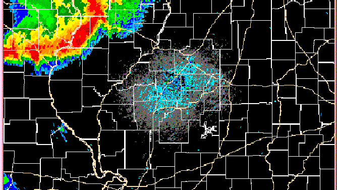
The Saharan dust is so dense and widespread that it could be seen from space on Thursday. NOAA’s GOES-EAST weather satellite spotted the first cloud of dust over the eastern Caribbean Sea and the Lesser Antilles, with an even bigger plume of dust emerging off the coast of Africa.
A satellite image of the tropical Atlantic Ocean on Thursday, July 6, 2023. A cloud of Saharan dust could be seen over the eastern Caribbean Sea, while another dust cloud was emerging off the coast of Africa. (NOAA/GOES-EAST)
“Saharan dust is common most years across parts of the Atlantic basin and sometimes spreads as far west as the Caribbean and Florida,” said AccuWeather Director of Forecast Operations Dan DePodwin. “The location and magnitude of the dust changes frequently throughout the season.”
Forecasters warn that while the dust is not a particularly rare occurrence, it could still impact people across the Southeast in the coming days.
When will Saharan dust reach the US?
The cloud of dust currently over the Caribbean Sea is predicted to reach Florida by Saturday and could extend toward coastal areas of Texas, Louisiana, Mississippi and Alabama by Sunday. This initial wave of dust may not be as extreme as the Saharan dust that spread across the Southeast in June of 2020, which was so massive it was dubbed the Godzilla dust cloud, but the upcoming event could still impact air qualityand make the sky appear opaque.
A dust-filled sky over Florida may also help to block out some sunlight to knock down temperatures by a few degrees compared to the heat during the first week of July. During the extended Independence Day weekend, temperatures across the state reached the mid- to upper 90s with AccuWeather RealFeel Sun™ Temperatures nearing 120 degrees in some towns. (emphasis added)
And the impending Saharan dust may be a preview of what’s to come next week.
A larger, more robust cloud of Saharan dust is being blown off the coast of Africa and will quickly cross the Atlantic Ocean. The dust is being carried by the trade winds that blow from east to west over the tropical Atlantic Ocean.
The thicker dust cloud is predicted to reach the eastern Caribbean by the end of the weekend and may approach Florida by Tuesday. If this forecast comes to fruition, it may cause air quality to worsen across Puerto Rico, the Dominican Republic, Haiti, Cuba and Florida.
People across the Gulf Coast who plan on spending extended time outdoors over the next week are encouraged to check the air quality forecast for their area due to the possible impacts of the dust.
While Saharan dust can affect everyone, there are groups that are more vulnerable to particulate pollution health effects than others, according to the Centers for Disease Control and Prevention (CDC). Children and babies, older adults and people with underlying lung conditions or chronic cardiopulmonary diseases are among those outlined by the CDC.
Saharan dust particles can irritate the skin and eyes in addition to worsening asthma symptoms and other respiratory and cardiovascular symptoms and events.
How will dust impact Atlantic tropic activity?
The widespread Saharan dust is putting a lid on tropical development across the Atlantic Ocean following a burst in activity in late June.
“Tropical waves, the origin of many tropical storms and hurricanes, thrive on a moist atmosphere,” DePodwin explained. “When Saharan dust is present, development of these waves can be impeded due to the atmosphere being drier than what is typical.”
With the Saharan dust forecast to become even more widespread across the Atlantic hurricane basin into next week, and with disruptive winds blowing over the ocean, it is unlikely that another tropical system will spin up in the coming days.
Now, if you do not see that HAARP is playing a major part in this bizarre weather and the Dimming of the skies, then I would suggest that you get your head out of the sand and realize that this is no conspiracy “theory.” Oh, it’s a Conspiracy alright and the joke is on us. BUT when our Lord Jesus comes to destroy the works of the devil, these HAARP demons won’t know what hit them!
In case you do not know about HAARP – here is an article you need to read:
Hazardous marine conditions are expected over the coastal and offshore waters where gale watches and warnings are in effect. For more information, see products from your local National Weather Service office and high seas forecasts issued by the National Weather Service.
— National Hurricane Center (@NHC_Atlantic) May 24, 2023
So what does "zero mile" visibility look like? Well, here's a spectacular view of our parking lot near the airport. Yes, there are cars parked just a few feet away.
SNOW FORECAST❄️: A Christmas week winter storm is expected to bring up to 2 feet of snow in and around the Great Lakes.
Blizzard conditions will also be likely in the Plains and Great Lakes Thursday-Friday, which will have devastating impacts on holiday travel. @SteveBenderWxpic.twitter.com/thFLNQrKbf
Models suggesting a 1058mb high could drop into the US next week in association w/ arctic air mass. Last week this same airmass produced a temp of 78 below zero in the Siberian tundra (often colder than the Arctic). Record highest pressure in lower 48 is 1064mb in Montana in 1983 pic.twitter.com/bGr286b8zp
Hurricane season in the Atlantic Ocean runs from June 1 to Nov. 30. In the Pacific Ocean, it starts May 15.
Preparing for a hurricane or tropical storm and gathering your resources before one hits is critical to ensuring your safety and protecting your property.
Here is a hurricane preparedness list and some tips to help you get ready for hurricane season.
Determine the risk to your area
First things first, determine what type of risks you face in the event of a landfalling hurricane or tropical storm.
The wind is the first thing that comes to mind for most when they think about hurricanes, and rightly so. These storms can produce some terribly damaging wind. However, one of the biggest threats from any tropical system is flooding. That flooding can come in two forms — storm surge along the coast or inland flooding from heavy rain. Tropical systems can also produce tornadoes as they come ashore and rip currents along beaches.
With that list in mind, determine what types of problems you might face during a hurricane or tropical storm. In most cases, it will be more than one or maybe even all of them. Knowing this helps you develop a hurricane preparation plan.
Create a hurricane evacuation plan
If you live in a coastal region, you’re most likely in some type of evacuation zone. Before a hurricane or tropical storm hits, you should determine whether you live in an evacuation zone. Some places handle evacuations by ZIP codes, while others handle it in predetermined zones. Your local or state emergency management office has maps available to help you determine whether you live in an evacuation zone.
Once you figure out your evacuation zone, start figuring out where you would go for shelter. Maybe it’s a relative who lives outside the area. Maybe it’s a hotel in a safe place. Maybe it’s a hurricane shelter opened by local officials.
Follow all the evacuation instructions that you’re being given by local officials. Most evacuees will be required to use a specific evacuation route to get out of town. Familiarize yourself with the route. Don’t get on the roads unless you’re told to do so. Unnecessary traffic slows down the evacuation process.
Don’t forget about your pets when developing your evacuation plan. Shelters and hotels may not allow animals. Pet hotels in the area may not be open in the event of a storm.
One last thing, make sure you bring important documents such as insurance paperwork with you.
Assemble your hurricane supply kit
You’ll need to assemble emergency supplies that you can use during and after a hurricane before one is bearing down on your area. People will flock to stores upon word of an approaching storm, so getting those supplies ahead of the rush will save you critical time and a lot of stress.
Here are some things the National Weather Service says you should include in your kit:
Enough non-perishable food, water and medicine to last each person in your family a minimum of three days.
Extra cash.
A battery-powered radio.
Flashlights.
A portable crank or solar-powered USB charger for your cell phones.
The Federal Emergency Management Agency also has a list of emergency items you should include.
Check your insurance policy’s hurricane coverage
The last thing you want to deal with during and after a storm is the insurance company. Give your agent a call now and make sure that your coverage is adequate to cover the risks that you may face during a hurricane or tropical storm.
It’s worth noting that standard home insurance policies do not cover flooding from a storm. If your area is prone to flooding, you should consider getting flood insurance. There’s a 30-day waiting period for most flood insurance policies, so sooner is better. You can get more information about the National Flood Insurance Program at floodsmart.gov.
Prepare your home for a hurricane
Before a storm hits, prepare your home for the storm.
Install storm shutters that will be helpful in providing protection from the wind for your windows and doors. According to the National Weather Service, a garage door is the most vulnerable part of a home. Make sure it can stand up to the wind.
Trim trees to prevent branches from falling into your house. Also, secure any loose items like patio furniture or garbage cans so that they don’t become projectiles during the storm.
The super pressure balloon will be launched on a test flight from New Zealand, on a potential 100-day journey. NASA will begin flight preparations in the early morning hours Thursday & will continue to evaluate real-time & forecast weather conditions throughout the morning.
A cluster of thunderstorms that produces destructive wind gusts for hundreds of miles and can impact millions of people is known as a derecho.
For meteorologists to classify a windstorm as a derecho – from the Spanish word for “straight” – the swath of straight-line wind damage it causes must cover a distance of at least 250 miles and include wind gusts over 58 mph along most of its path, as well as several, well-separated 75-mph or higher gusts, according to NOAA’s Storm Prediction Center.
Derechos can occur at any time of the year but are more common when a clash of air masses happens during the spring and summer.
The damaging-wind events vary in size, but it is not uncommon for winds to exceed more than 100 mph and produce tornado-like destruction for several hundred miles.
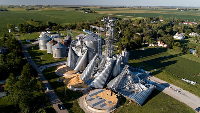
In this aerial image from a drone, damaged grain bins are shown at the Heartland Co-Op grain elevator on Aug. 11, 2020, in Luther, Iowa. Iowa Gov. Kim Reynolds said early estimates indicated 10 million acres, nearly one-third of the states land used for crops, were damaged when a powerful storm battered the region a day earlier.
(Daniel Acker / Getty Images)
One of the most significant derecho events in U.S. history occurred throughout much of the Midwest during the summer of 2020.
During the event, winds gusted upward of 140 mph, causing more than $7.5 billion in damage.
If you are in the path of a high-wind event such as a derecho, it is advised that you get indoors and move away from windows and doors.
⚠️ The forecast is calling for heavy, wet snow for much of the state tomorrow. Follow these tips to shovel snow safely: ✔️ take it slow ✔️ push snow instead of lifting ✔️ take breaks ✔️ drink water ✔️ STOP shoveling and CALL 911 if you experience any heart attack symptoms pic.twitter.com/IRY2tnn3Mh
— PA Department of Health (@PAHealthDept) March 11, 2022
I have created this site to help people have fun in the kitchen. I write about enjoying life both in and out of my kitchen. Life is short! Make the most of it and enjoy!
There are two ways to be fooled. One is to believe what isn’t true; the other is to refuse to believe what is true. —Soren Kierkegaard. "...truth is true even if nobody believes it, and falsehood is false even if everybody believes it. That is why truth does not yield to opinion, fashion, numbers, office, or sincerity--it is simply true and that is the end of it" - Os Guinness, Time for Truth, pg.39. “He that takes truth for his guide, and duty for his end, may safely trust to God’s providence to lead him aright.” - Blaise Pascal. "There is but one straight course, and that is to seek truth and pursue it steadily" – George Washington letter to Edmund Randolph — 1795. We live in a “post-truth” world. According to the dictionary, “post-truth” means, “relating to or denoting circumstances in which objective facts are less influential in shaping public opinion than appeals to emotion and personal belief.” Simply put, we now live in a culture that seems to value experience and emotion more than truth. Truth will never go away no matter how hard one might wish. Going beyond the MSM idealogical opinion/bias and their low information tabloid reality show news with a distractional superficial focus on entertainment, sensationalism, emotionalism and activist reporting – this blogs goal is to, in some small way, put a plug in the broken dam of truth and save as many as possible from the consequences—temporal and eternal. "The further a society drifts from truth, the more it will hate those who speak it." – George Orwell “There are two ways to be fooled. One is to believe what isn’t true; the other is to refuse to believe what is true.” ― Soren Kierkegaard
Following in the spirit of Britain's Queen Boudica, Queen of the Iceni. A boudica.us site. I am an opinionator, do your own research, verification. Reposts, reblogs do not neccessarily reflect our views.